The Doherty High School Expansion Project
And its impact on Newton Hill’s Public Amenities
The information on this page is sourced directly from the Doherty High School Building Committee Meetings and its supporting documents. Below are some of the key documents that highlight the scope of the Doherty High School Expansion Project and its impact on Newton Hill at Elm Park, including the 8 acres of ‘school department property’ that has functioned as park/green space since the school was built.
public records:
Doherty Memorial High School Feasibility Study Preferred Schematic Report updated February 18th, 2020 (1,108 page document, we’ve annotated and organized here)
Videos of Doherty High School Building Committee Meetings held on Monday, December 9, 2019 and Wednesday, December 18, 2019
Doherty Memorial High School Schematic Design Document (764 pages) (Download to be able to read)
June 15th, 2020 Doherty High School Building Committee Meeting presentation
June 29th, 2020 Doherty High School Building Committee Meeting Presentation
Doherty Memorial High School MSBA Schematic Design Document (1219 pages) (Download to be able to read)
Newton Hill’s Future at Risk:
The following pictures have been sourced directly from the Doherty High School Building Committee documents listed above and cited as such, highlighted here along with outstanding concerns about the impact of the proposed construction on public space and public and historic resources.
concern: building size/height, inaccessible turf field, elimination of public green space, destruction of historic stone walls and beech trees, construction of new retaining walls
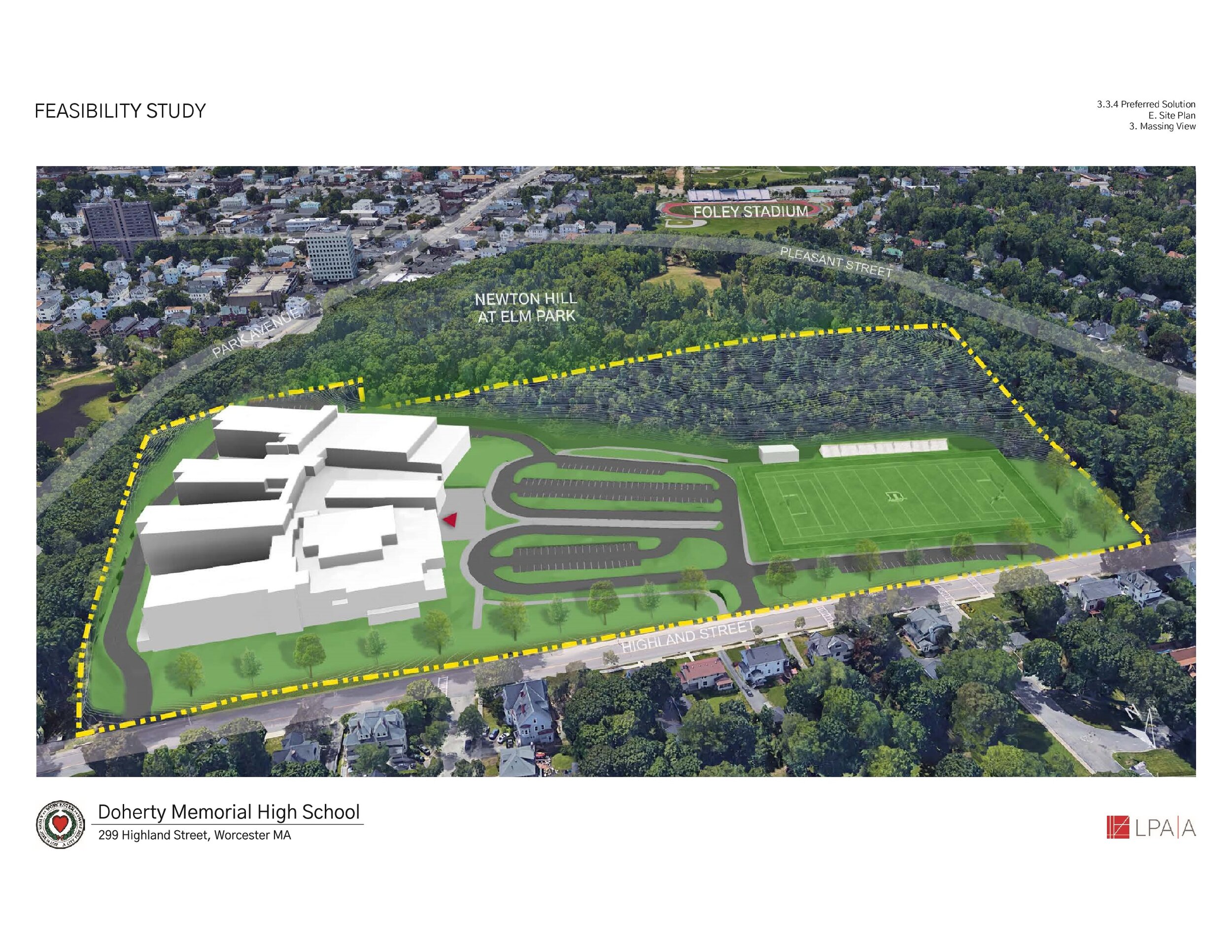
Photo source: Doherty Memorial High School Feasibility Study Preferred Schematic Report, page 996
Architectural rendering showing the proposed 420,000 square foot building, with 6 stories, an artificial turf field (to have no access for public use), and the elimination of all public green space (surrounding the school), the destruction of the historic stone wall and staircase (along Highland Street), and the removal of all heritage Beech trees fronting Highland Street.
concern: building height from street level view and obfuscation of park views; inaccurate depiction of trees

Photo source: June 15th, 2020 Doherty High School Building Committee Meeting presentation, page 22
The Friends of Newton Hill have passed along the above rendering to the Massachusetts Historical Commission. This rendering visualizes the proposed school from the Highland Street perspective (aerial view, rather than street level). Trees shown here are not saved from the original site, all are newly planted and depicted at mature age (20+ years, not newly planted).
proposed park rendering

Photo source: Doherty Memorial High School Schematic Design Document, Attachment D, page 704
This picture was also provided to the Massachusetts Historical Commission.
concern: destruction of publicly accessible, green space - athletic fields

Photo source: Doherty Memorial High School Feasibility Study Preferred Schematic Report, page 376
An aerial view of the school property as it exists today, including 8 acres of open - publicly accessible - recreational space containing baseball/softball field. This open space will be destroyed, as it is the exact location of the proposed 420,000 square foot building
concern: construction of retaining walls and paved surface encroachment into parkland

Photo source: June 15th, 2020 Doherty High School Building Committee Meeting presentation, page 8
This picture was also provided to the Massachusetts Historical Commission.
This rendering displays the features of the proposed site, including newly planted trees along the east side of the school and along Highland Street, and retaining walls surrounding the property.
The feature marked #5 is a new wall to replace the historic stone wall and beech trees along Highland Street. Still waiting on the details for the retaining walls that will be present on the new school site.
The feature marked #4 is legally within park land. That space is currently paved over and is part of the Doherty parking lot, an encroachment onto parkland that occurred originally during Doherty’s construction and replicated here in the proposed construction.
concern: new paved surfaces will eliminate publicly accessible green space and increase amount of paved surface on site
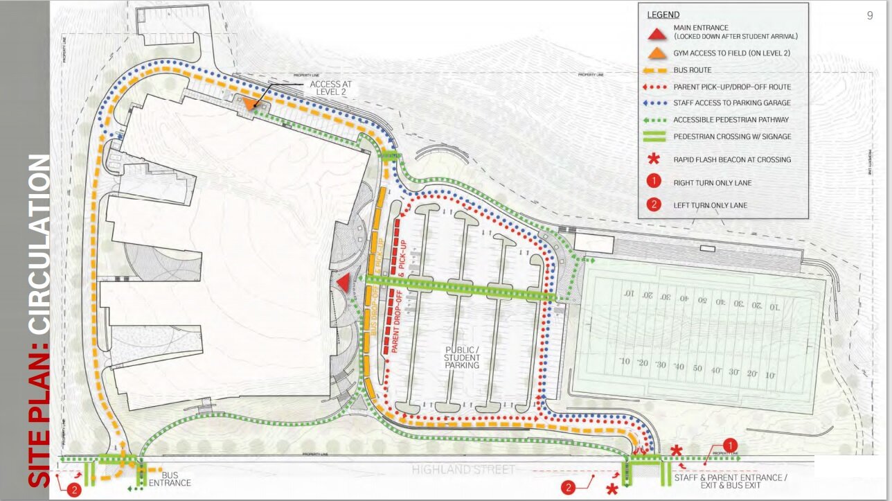
Photo source: June 15th, 2020 Doherty High School Building Committee Meeting presentation, page 9
This picture was also provided to the Massachusetts Historical Commission.
This rendering displays a circulation chart proposing the flow of motor vehicle and pedestrian traffic around the proposed construction.
concern: inaccurate depiction from current park entrance

Photo source: June 15th, 2020 Doherty High School Building Committee Meeting presentation, page 25
This picture was also provided to the Massachusetts Historical Commission.
This rendering displays a view of the proposed building from the back - its south side. This is where the current entrance to the park through the Doherty parking lot is and is the current location of the park’s free disc golf course’s hole #1.
concern: inaccurate depiction of new road construction adjacent to park land

Photo source: Doherty Memorial High School Schematic Design Document, page 715
This picture was also provided to the Massachusetts Historical Commission.
This rendering displays a view of the eastern side of the proposed building. This rendering is missing the new road that has been proposed and depicted in the other renderings that will be laid between the proposed school building and the edge of Newton Hill/Elm Park. The trees depicted do not represent an accurate view of the eastern view of the school, as most of the trees currently in that location will be removed.
concern: building height vis-a-vis summit

Photo source: June 15th, 2020 Doherty High School Building Committee Meeting presentation, page 20
This picture was also provided to the Massachusetts Historical Commission.
This illustration shows the height differential of the proposed school as compared to park/geological features.
The proposed high rise school building has been increased from 620’ to 622’, not factoring in any equipment that will be located on top of the building. This is a little less than 50’ lower than the height of the summit of Newton Hill.
concern: building height will obscure park views

Photo source: June 15th, 2020 Doherty High School Building Committee Meeting presentation, page 10
This picture was also provided to the Massachusetts Historical Commission.
This illustration shows the slope of the proposed construction terrain compared to Highland Street.
The size of the proposed building, depicted here, will obscure any eastern city views from the park. The presence of trees is also substantially diminished compared to what currently exists on the site.
concern: building height will obscure park views

Photo source: June 15th, 2020 Doherty High School Building Committee Meeting presentation, page 11
This picture was also provided to the Massachusetts Historical Commission.
This illustration shows the slope of the proposed construction terrain compared to Park Ave on the eastern/southern side of the building.
The building’s height will obscure the green, natural park views that currently exist from Park Ave.
concern: school dept.’s ground maintenance record

Photo source: Doherty Memorial High School Schematic Design Document, Attachment D, page 693
This picture was also provided to the Massachusetts Historical Commission.
This photo shows how warn out and under-maintained the existing school property is.
AT RISK: green, public space surrounding school

Photo source: Doherty Memorial High School Schematic Design Document, Attachment D, page 695
This picture was also provided to the Massachusetts Historical Commission.
This photo doesn’t show a high rise. All of the green, public space and trees surrounding the school will be destroyed.
concern: view from main park entrance at doherty parking lot

Photo source: Doherty Memorial High School Schematic Design Document, page 732
This picture was also provided to the Massachusetts Historical Commission.
This graphic displays where the pictures were taken that were used to create the renderings of the proposed construction. Those pictures themselves can be found on page 764 of the Doherty Memorial High School Schematic Design Document produced by the architects LPAA.
The Friends of Newton Hill is requesting a rendering depicting the view of the proposed construction from hole #1 of the disc golf course, to visualized the back of the high rise building that will become the main view from within the historic park’s most frequented park entrance.
concern: obfuscated view of newton hill and sunset

Photo source: June 15th, 2020 Doherty High School Building Committee Meeting presentation, page 30
This picture was also provided to the Massachusetts Historical Commission.
This rendering depicts a winter view of the proposed construction from Elm Park. The skyline in the depiction does not look anything like a historic public park, it appears more like an apartment complex. The presence of the tall building will obscure and reduce the beauty of sunsets as seen from Elm Park proper.
concern: inaccurate depiction of tree line

Photo source: June 15th, 2020 Doherty High School Building Committee Meeting presentation, page 31
This picture was also provided to the Massachusetts Historical Commission.
This rendering depicts a summer view of the proposed construction from Elm Park. The proposed construction is not very visible because of the tree canopy, as photographed recently. All of the trees shown herein will be cut down, as shown in previous renderings of the site. This is not an accurate rendering, as the proposed school building will undoubtably be visible in both the winter and the summer.
concern: obfuscated view of newton hill

Photo source: June 15th, 2020 Doherty High School Building Committee Meeting presentation, page 32
This picture was also provided to the Massachusetts Historical Commission.
This rendering depicts a winter view of the proposed construction from Elm Park. The proposed construction appears more like an apartment complex or technology park, rather than a historic public park.
concern: obfuscated view of newton hill

Photo source: June 15th, 2020 Doherty High School Building Committee Meeting presentation, page 28
This picture was also provided to the Massachusetts Historical Commission.
This rendering depicts a winter view of the proposed construction from the intersection of Highland St and Park Ave. The proposed construction will be very visible during the winter months.
concern: inaccurate depiction of tree line

Photo source: June 15th, 2020 Doherty High School Building Committee Meeting presentation, page 29
This picture was also provided to the Massachusetts Historical Commission.
This rendering depicts a summer view of the proposed construction from the intersection of Highland St and Park Ave. This rendering suggests that the proposed construction will not be visible from the intersection. However, the tree canopies depicted here that show the building obscured from view have been tagged for removal and will be destroyed as part of the construction. In the presentation, it was stated that the interior layout of the proposed building will be in pod/modular sections and that each pod will boast wonderful views of Elm Park - referred to as ‘Pods on the Park’. Those views will not be possible from the proposed building unless more than 25 trees are cut down along the East-West Trail within that Newton Hill section of Elm Park.
at risk: 1890s historic stone wall

Photo source: Doherty Memorial High School Schematic Design Document, Attachment D, page 702
This picture was also provided to the Massachusetts Historical Commission.
This photo shows the wall and stair case along Highland Street that were built in 1890. The proposed construction will destroy this historic park feature and replace it with a new one. The project documents claim that the wall and stairs aren’t historic because they are not included on the historic registry.
at risk: 1890s historic stone wall

Photo source: Doherty Memorial High School Schematic Design Document, Attachment D, page 707
This picture was also provided to the Massachusetts Historical Commission.
This photo shows the wall along Highland Street and its current, deteriorated condition. These photos were included to justify the destruction of this historic feature. The wall was patched by the City within the past year. It is in such a deteriorated condition due to lack of maintenance. That section of park property was removed from park jurisdiction/maintenance when the school department obtained the land in the 1960s.
at risk: historic beech trees

Photo source: Tree Assessment Summary Report, page 27
This graphic displays the location of all of the historic beech trees that will be cut down. There are none of these large, beautiful trees depicted in any of the architectural renderings of the proposed building. The architects have stated that they haven’t decided what they are going to do with the trees - but this statement conflicts with the renderings that have been submit as part of the official design. These trees are historic, over 100 years old, and in healthy condition.
at risk: historic beech trees

Photo source: Tree Assessment Summary Report, page 44
This map displays all of the trees that were visually evaluated, including a number that are located within the Newton Hill section of Elm Park and not on school department property. The destruction and removal of trees from public park land would be a violation of Article 97, which protects historic park land.
The architects have insisted that the East-West Trail and its trees will not be impacted. Their documentation suggests that more than 10 trees along the East-West Trail will be cut down.
at risk: TREES on east-west trail

Photo source: privately taken photograph, May 2020
This photo shows the East-West trail southbound into Newton Hill at Elm Park. These trees are located on protected public park land. As seen above, we are advocating for their preservation.
at risk: TREES on east-west trail

Photo source: privately taken photograph, May 2020
This photo shows the East-West trail southbound into Newton Hill at Elm Park, closer to the corner of the school property up the East-West Trail. These trees are located on protected public park land and we are advocating for their preservation.